Pokeno - the Waikato War
“Pokeno” - literally po; night; keno: underworld. May mean “place of refuge” (Reed).
This is the first significant site of the Waikato War when heading South from Auckland.
Below: The Queen's redoubt at Pokeno (1862-68)
BACKGROUND
The Pukekohe district (of which Pokeno is part) is an extremely fertile area, ideal for growing crops on rich volcanic soils. In the 1860’s Pokino (later Pokeno) was a thriving Maori village and economic hub. Local Maori were engaged in a lucrative agricultural trade with Auckland as well as overseas. They also owned the local mill which processed flour and maize.
Pokino, along with most of the Maori holdings between Auckland and Mercer, became collateral damage in the Waikato War - sacked, pillaged and destroyed after being declared, on a most flimsy pretext, as disloyal to the Crown.
Governor George Grey’s invasion plan for the Waikato required an extensive military supply route - the Great South Road was constructed (begun 1 January 1862) ending here at the Queen’s Redoubt - which functioned in tandem with the Waikato River landing, 5 km south, at Mercer (where river steamers and other craft delivered more troops and supplies from Auckland). At Pokeno Grey amassed forces, munitions and support for his proposed invasion southwards along the river.
Built in 1862, the Queen’s Redoubt was the largest earth-walled fortification ever constructed by Imperial forces in New Zealand. It was one hundred yards (c.100m) square internally and protected by an immense ditch 6m wide and 2.4m high. Capable of housing 450 men, it was planned, and served, as the launching-point and main forward base for the British invasion of the Waikato under General Cameron - (12 July 1863).
Thousands of troops passed through here on their way to the series of conflicts further south. However, there was no military engagement here (aside from the destruction of the Maori village) - the Maori constructed their main defensive sites further south at Rangiriri and Peterangi.
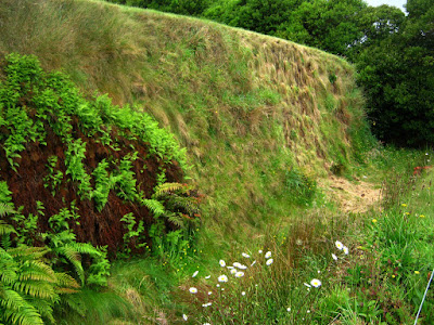
Today, very little remains of the Queen’s Redoubt earthworks - just a deep ditch and steep bank beside the road. Although housing along Selby Street now occupies part of the site, well over half of it actually still exists, albeit now hidden beneath a featureless paddock.
In June 1999 the Queen’s Redoubt Trust was formed to acquire the redoubt site, under which some remediation of the original earthworks has begun and the beginnings of an interpretation and research centre established. This was unfortunately closed when I visited (on a Monday) as it is only open on Saturdays from 10am-2pm.
See http://www.queensredoubt.co.nz/main.cfm?id=11
for information.
 | ||||||||||||
| The site today |
 |
| Remains of the earthworks |
 |
| Remains of the earthworks |
 |
| The visitor centre |


Comments
Post a Comment