How Captain Lloyd Lost his Head - Part One

Hauhau warriors prepare to attack, kill and decapitate a group of soldiers led by Captain Lloyd - Ahuahu, North Taranaki, 6 April 1864.
This dramatic watercolour by Major Gustavius von Tempsky entitled “A Maori Ambush” depicts Pai Marire/Hauhau warriors preparing to attack a troop of soldiers and militia from the Kaitake Redoubt engaged in destroying a crop of maize planted by local Maori, in North Taranaki. This action was part of an “bush scouring” tactic by Imperial forces aimed at destroying Maori food resources and shelter in order to render them less capable of any resistance to the taking of their land.
CONTENTS:
History - including Taranaki Herald report April 9 1864
Location and access
Photograph of my visit to the site November 2018
Google maps
HISTORY
In “Frontier’ Peter Maxwell describes the unwary foe in the scene above as being first cut down by shotgun fire from the bush, then attacked with tomahawks by Maori chanting “Hau Hau”. Seven fell dead, the rest fled back to the redoubt. The relief force made “...a grotesque discovery. The seven fallen men had been stripped naked and beheaded - the red wounds highlighting the startling whiteness of the English skin. Despite a search neither the clothes nor the heads were to be found.” (p.84).
Literally ‘Hau’ = ‘wind’
Although Pai Marire/Hauhau followers used a mish-mash of Maori, European and gibberish words in their rituals, it is not understood what the attackers meant by their chants of ‘Hau Hau” in this circumstance, however in media and official reports from Ahuahu onwards Te Ua’s disciples became “Hauhau” - and the word was to send paroxisms of alarm through settler communities for decades.


[The newspaper excerpts above are from The Taranaki Herald, Volume XII, Issue 610, 9 April 1864
CONTENTS:
History - including Taranaki Herald report April 9 1864
Location and access
Photograph of my visit to the site November 2018
Google maps
HISTORY
In “Frontier’ Peter Maxwell describes the unwary foe in the scene above as being first cut down by shotgun fire from the bush, then attacked with tomahawks by Maori chanting “Hau Hau”. Seven fell dead, the rest fled back to the redoubt. The relief force made “...a grotesque discovery. The seven fallen men had been stripped naked and beheaded - the red wounds highlighting the startling whiteness of the English skin. Despite a search neither the clothes nor the heads were to be found.” (p.84).
Literally ‘Hau’ = ‘wind’
Although Pai Marire/Hauhau followers used a mish-mash of Maori, European and gibberish words in their rituals, it is not understood what the attackers meant by their chants of ‘Hau Hau” in this circumstance, however in media and official reports from Ahuahu onwards Te Ua’s disciples became “Hauhau” - and the word was to send paroxisms of alarm through settler communities for decades.
Sourced from https://paperspast.natlib.govt.nz/newspapers/TH18640409.2.7 ]
The Lloyd incident was soon followed by a frontal attack by a larger group of Hauhau warriors on the British redoubt at Sentry Hill (near Waitara) on 30 April, and then on 14 May by a battle on Moturoa Island on the Whanganui River between Hauhau forces from Taranaki, plus upriver converts, and “loyalist” Maori from Wanganui.
At Sentry Hill the attackers walked slowly towards the redoubt in broad daylight holding up their right hands and chanting “Hauhau” - evidently believing that this ritual would deflect the Imperial fire over their heads. Peter Maxwell again (p.93): “The British held their fire, while the attackers held their breaths, putting their faith to the test, awaiting the first bullets...” At fifty yards distance the order to “fire” was given - fifty Hauhau fell dead, as many were wounded.
Their faith was shaken, but remained undaunted for years.
The violent and “fanatical” nature of these three violent clashes sent shockwaves throughout the settler communities and the Colonial Government. Governor Grey was quick to capitalize on the fear engendered by these and other events in 1864 ( including the conversion of the second Maori King (Tawhiao) to Hauhauism in November): he set out to crush what Belich describes as “the secondary bastion of Maori independence - the South Taranaki tribes ( “The New Zealand Wars” p.206). And thus began what is termed the “Second Taranaki War”.
These attacks, shortly after the fall of Orakau in the Waikato, appear to be be in contravention of the pacifist teachings of Te Ua - the prophet and founder of the Pai Marire (“The Good and Peaceful”) faith. This discrepancy is examined in detail in “Hauhau - The Pai Marire Search for Identity” by Paul Clark.
See my blog entry:
“How Captain Lloyd Lost his Head, Part 2” for more on Te Ua, the fate of the Captain’s head and the role of smoked European heads in the spread of Hauhauism.
LOCATION & ACCESS:
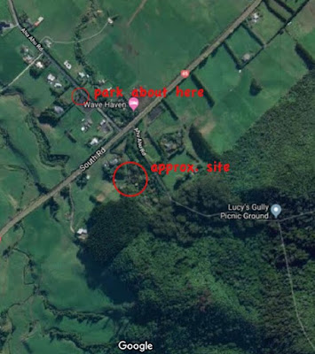
This site is on private land on the lower slopes of Mt Patuha, about 10km west of New Plymouth, just past Oakura, on the inland side of Hwy 45.
Turn right into Lower Ahuahu Road. After 200 meters or so is a farm gate on the left. Stop here and look back towards Mount Taranaki, The general area of the massacre site is visible and is, I understand, behind the farmhouse - as indicated below.
Although the narrow Upper Ahuahu Road leads past the site, it runs through dense bush, so nothing can be seen of the location (to the right) at all.
“Ahuahu” - “ahu’ = “to pile up”. “Ahuahu” may refer to the Maori method of cultivating kumera, where earth is piled up around the plants.
November 2018:


GOOGLE MAPS:


The Lloyd incident was soon followed by a frontal attack by a larger group of Hauhau warriors on the British redoubt at Sentry Hill (near Waitara) on 30 April, and then on 14 May by a battle on Moturoa Island on the Whanganui River between Hauhau forces from Taranaki, plus upriver converts, and “loyalist” Maori from Wanganui.
At Sentry Hill the attackers walked slowly towards the redoubt in broad daylight holding up their right hands and chanting “Hauhau” - evidently believing that this ritual would deflect the Imperial fire over their heads. Peter Maxwell again (p.93): “The British held their fire, while the attackers held their breaths, putting their faith to the test, awaiting the first bullets...” At fifty yards distance the order to “fire” was given - fifty Hauhau fell dead, as many were wounded.
Their faith was shaken, but remained undaunted for years.
The violent and “fanatical” nature of these three violent clashes sent shockwaves throughout the settler communities and the Colonial Government. Governor Grey was quick to capitalize on the fear engendered by these and other events in 1864 ( including the conversion of the second Maori King (Tawhiao) to Hauhauism in November): he set out to crush what Belich describes as “the secondary bastion of Maori independence - the South Taranaki tribes ( “The New Zealand Wars” p.206). And thus began what is termed the “Second Taranaki War”.
These attacks, shortly after the fall of Orakau in the Waikato, appear to be be in contravention of the pacifist teachings of Te Ua - the prophet and founder of the Pai Marire (“The Good and Peaceful”) faith. This discrepancy is examined in detail in “Hauhau - The Pai Marire Search for Identity” by Paul Clark.
See my blog entry:
“How Captain Lloyd Lost his Head, Part 2” for more on Te Ua, the fate of the Captain’s head and the role of smoked European heads in the spread of Hauhauism.
LOCATION & ACCESS:
This site is on private land on the lower slopes of Mt Patuha, about 10km west of New Plymouth, just past Oakura, on the inland side of Hwy 45.
Turn right into Lower Ahuahu Road. After 200 meters or so is a farm gate on the left. Stop here and look back towards Mount Taranaki, The general area of the massacre site is visible and is, I understand, behind the farmhouse - as indicated below.
Although the narrow Upper Ahuahu Road leads past the site, it runs through dense bush, so nothing can be seen of the location (to the right) at all.
“Ahuahu” - “ahu’ = “to pile up”. “Ahuahu” may refer to the Maori method of cultivating kumera, where earth is piled up around the plants.
November 2018:
 | |
| Ahu Ahu junction - looking west |


 |
| The site from Lower Ahu Ahu Road |
 |
| I understand the site to be approx. here |


Comments
Post a Comment